Tampilkan postingan dengan label 8. Tampilkan semua postingan

We Are OFF! NY to Annapolis October 8 10 268 Miles

Our first problem was discovered when we had to use the dinghy to go to dinner on City Island because the Clubs launch service ends at 6 pm in the waning days of the season: it started right up but stopped in five seconds. So we paddled.  And the night of the seventh was unpleasantly rocky on the mooring due to strong SW winds kicking up big chop in Eastchester Bay, impeding sleep.

The passage was from 9:45 am on the eighth until 7:30 am on the tenth, 45.75 hours with a two hour "stop" to be discussed later, so 43.75 hours underway. The first of the two days (NYC and the Atlantic coast of New Jersey) was warmer than expected for the season, both day and night, with sunny clear skies and a big full moon; the second of the days (Delaware Bay, the C and D Canal and Chesapeake Bay) was raw and cloudy but not frigid and not rainy. This chart, created by Jims Spot device shows our route, except that it connects the dots every four hours or so and hence cuts off the corners and shows us crossing land. [Image to be added.]
We actually left, after mango pancakes, about an hour too early due to my impatience so we did not experience the favorable tide while we fought strong headwinds until near Hellsgate when the tide started flushing us out of NY Harbor. A tug with four barges (2 x 2) came up behind us near Hellsgate and called ILENE by name to advise that we would apparently be going through Hellsgate together and that his four barges would be swinging to port. I did a short 360 degree loop to let him pass and observed that his tow did indeed sweep far to his port side and "crab" through the most problematic tidal strait of the passage on a diagonal. We passed parallel to the FDR Drive with its snarled traffic on which I drive so often to get to the Club.


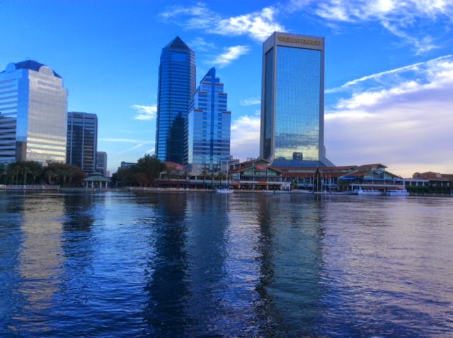
Here is the Freedom Tower to the left, currently New Yorks tallest structure, and a tower of the Brooklyn Bridge to the right, which held that title in the 1880s.


We put up sails, starting with double reefed main and small jib, after we passed Governors Island and we were on starboard tack all the way to Cape May, though we gradually shook out the reefs and changed back and forth to the genoa when passing through periods of apparent winds of 20-25 knots and periods where they were in the mid teens. The Verranzano Bridge, our ninth of the passage, was emotionally my last point in New York until around May, 2015.
Unlike the similar passage on Pandora about two weeks before, on which the wind was never forward of the beam, on this trip it was almost never aft of the beam, though rarely close hauled and predominantly about 60 degrees off the bow. 

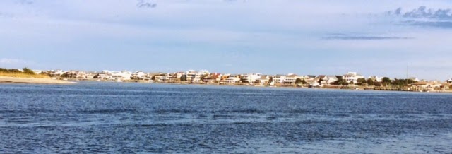
Jim, who made the trip on both boats is a great man to have aboard. He is a fellow Cornellian, an engineer and very knowledgeable as a sailor though he wears his experts mantle lightly, without a trace of the arrogance that some experts have -- laid back and a pleasure to sail with. He agreed to my request to sleep the earlier part of each night and stand the later night watch.  During our first night I was "racing" a green light that started off our port bow. At times he would get ahead and by changing sails, at times, I would get ahead. Our speed varied from 3.5 to 8.1 knots depending on the wind. When very close I hailed the "sailboat with another sailboat on your port quarter", identified ILENE and thanked him "for keeping me awake last night". He reciprocated the thanks and identified himself as "Momo" a Valiant 40, here shown off  Wildwood,
bound for Florida with a planned stop for a day in Cape May harbor. I told him I hoped we would meet up with them in Florida or along the way. He is a very good sailor because ILENE is a faster boat but he kept up.

Jim took the watch for most of the passage up Delaware Bay, in which we avoided the worst of the adverse tide. Having rounded Cape May at about 9 a.m., using the inside passage a hundred yards off the beach, with main and engine but no headsail, Jim suggested a diagonal course, away from but toward the shipping channel at Miah Maull light, after which we stayed just outside the channel on its right side almost all the way up. A tug with barges ran near adjacent to us most of the way and we put up the headsail when possible to gain speed and sailed without engine, close reaching on port. Unfortunately, when the tug got ahead of us during lighter winds, we got long doses of his diesel fumes. About 5-10 miles before the Canal, when we are slightly ahead of him, I called on VHF and told him our plan to cut across his bow to get to the other side of the channel in anticipation of our left turn into the Canal and he replied "OK".

As we entered the canal Jim came up with the good idea to stop for a couple of hours to avoid the worst of the adverse tidal flow. We would tie up for free at a dock in the Summit North Marina on the north side of the Canal to have dinner in their excellent Aqua Sol Restaurant. And we shared a bottle of red and a nice assortment of appetizers while motoring in the canal. This is the same marina where ILENE spent a night on our last trip in June 2012 and where Pandora went in for fuel two weeks ago. But on our way in, going slowly, of course, we went aground. We used the preventer to swing the boom, with Jim sitting on its end, out to port, in an effort to tilt the boat and break us free. No luck, we were stuck hard. And we created this lead line, the old fashioned depth meter, out of a green divers weight, a wire wrap, a length of light line and red tape to mark where the wet part old the line ended.

Yep, we were stuck alright and it was mud, which you can see,  dried on the bottom of the weight. What to do? Wait for the tide to come in and float us off. I took the watch and two hours later, at about ten, I saw us drift, turned on the engine and woke Jim.  We motored to the inner end of the cul de sac, turned in the deep turning basin and headed out of there.  Then I slept for four hours until 2 a.m. while Jim took us out of the Canal and into the Bay.  I took the watch from 2 until 7:10 a.m., when GPS put us ten minutes from the red daymark guarding Back Bay harbor of Annapolis, where Jim lives with Ann and where we docked at Bert Jabins Marina -- where ILENE had stood on the hard during the winter of 2005 in which we bought her.
Ann came over to take us to breakfast at Grumps, an Annapolis breakfast institution, where no two coffee mugs ever match. But the Captain ordered another batch of pancakes and put Jim to work peeling mangos for the three of us.
Then how to best utilize the time before Lenes arrival at about 4 pm. Well the most critical task was fixing the outboard, the engine of our car. And it being Friday, when mechanics are at work, I searched and found Steve of A and B Yachtsmen, who disassembled the carburetor, cleaned the rust from it, and emptied our fuel tank and line. She runs again! We are across the dock from a beautiful Tayana 55, "Karina"
owned by Dr. Miles (both M.D. and a boat doctor) and Ann, who are leaders in the Caribbean 1500. Ann gave Ilene a lot of good advice about sailing with cats in 2010 and unfortunately their cat has gone to heaven. I introduced myself as a graduate of the 2010 run and he pretended to remember me and invited us to an Alumni reunion we attended that night.

Before that I washed Ilenes salt crust and New York grime and freshened our water supply, cleaned up the interior a bit and took a shower and a nap. Lene and Witty look happy to be here and we got a good nights sleep.

The adventure has begun!
Read More..

HYC Cruise Day 8 August 1 Block Island RI to Stonington CT 18 6 Miles

Ohana left Block first, at about 7:30, after fueling up at Champlins dock, where he had to slither into a relatively short space between two megayachts on the fuel pier. He is heading as far west as he could get today, but later advised that he would not stop before City Island where he will arrive tomorrow. Sunset from Ohana.

ILENE left next, at 8, after raising and securing the dink, Again, the mooring painter hardly had time to get wet before the next boater picked it up. Today was a good sailing day, we put up full sails immediately after leaving Blocks channel and sailed all the way into Stonington on a port tack. Not a white knuckle speed day, what with ILENEs dirty bottom (Barnacle Buster didnt get to us before the cruise) but speeds between four and six knots depending on the wind. We picked up a mooring from Dodsons at noon and spent a few hours aboard before going ashore to tour the land. This is my first time here that coincided with the annual "Stonington Day" festival -- a lot of craft booths on the green. Long hot showers at Dodsons.

We heard True North call the Yacht Club, where Blast is also now, on outside berths. I had mentioned how packed in the boats were at Paynes Dock in Block. Ernie provided this photo. This is way too close!
We took Dodsons free launch from shore to the YC for dinner with a stop at this "cruise ship" out of Mystic in the harbor where its guests embarked her.

Also joining the cruise and on a mooring is "No News", Ken and Camilles Nonesuch, They are active cruisers but this is No News first Harlem Cruise and they love the extra room their new boat has. They will detach tomorrow and join us again in Centerport.

Dinner for ten at a big round table at the Yacht Club [photo on PC Martys camera will be added here later] was delicious and long. We just sat around telling stories long after the foood was gone.

On the walk back to Dodsons to get the launch to our boats we showed Ken and Camille the location of the 24 hour, freshly caught fish store, with payment of the marked prices by the honor system. But it was closed, sadly an apparent victim of lack of honor.
Read More..

December 1 3 Kingsley Plantation to Jacksonville and two Lay Days There 19 8 Miles

The passage, under motor, was uneventful. I was a bit disappointed to miss out on the tide up the St. Johns River. If we had started a bit later we would have caught more favorable tide.  This large suspension bridge had a high tech industrial appearance, less graceful than others, I thought.
 We passed a large cruise ship about ten miles before the city and waved to the passengers. I had not known that Jax was a cruise ship port. The trip up the river about 15 miles reminded me a bit of Norfolk with a large military presence, and huge commercial shipping. Watching the mammoth cranes at work -- sliding out and picking up or putting down shipping containers so quickly was rather amazing. They must have a computer program to tell it what to do because each trip out over the water between ship and shore involved two containers -- one off and one on.
Jacksonville was named after President Andrew Jackson who made his name by killing Native Americans in Florida, and is the largest city we have visited since leaving New York, almost two months ago.
Jacksonville Landing, on the river, at the heart of the downtown area was apparently intended as a version of the commercial activities of New Yorks South Street Seaport Museum. But it has fallen on hard times and the stores are mostly fast food restaurants. (So we ate at Hooters, a first time experience for me as was eating a corn dog for lunch the next day).  But the City offers its seawall, perhaps 200 yards of floating dock -- free -- for up to three nights. And there is water so ILENE got a thorough bath, but there is no electric, showers or help getting on or off. The Landing has a bad reputation for subjecting boaters to petty crime and pan handling. An alternative is a different free municipal marina where one can also get electricity for $8.00 per night, and which is not near pan handlers. But it is 1.5 miles from the downtown area, we did not fear panhandlers and did not experience any problems.
They say you have to raft up to other boats -- up to five abreast!!  -- if there are more boats than wall space. This could be quite difficult considering the current that runs in the river. But we were the only boat there when we arrived in the early afternoon, and no rafting was needed during our three nights; and we could have stayed longer had we wanted. The photo was taken after we left, and the only boat is the one just to the left of where we were tied up, below the Hooters.
We visited the Cummer Museum. Not a bad try for a smaller city like this. It was in the Cummer mansion, with additional buildings and had three lovely formal gardens out back, fronting the river, English, Italian and the third by Frederick Law Olmstead, designer of New Yorks Central Park. The city has a municipal trolley- looking bus system. Its route is listed on the tourist maps and would have taken us to the museum $.75 per person, one way. We waited for almost an hour before some kind person showed us the inconspicuous sign which had been pasted up that said that service had been discontinued as of the day before. So we took a cab, walked to the new Fresh Market nearby and got another cab back to the boat.  I also visited a somewhat disorganized maritime museum located in JVille Landing, and we took the free skyway, an elevated railroad that connects different parts of the city (sort of like the systems at New Yorks airports) to an excellent and popular restaurant, B.B.s, at the end of the line on the other side or the river and walked back across the Main Street Bridge.
We were lucky to make this bridge opening on our way in. There was construction and all of the associated equipment had to be removed before they could raise the bridge, causing a delay that permitted us to avoid waiting almost an hour for the next opening.
We enjoyed visitors here: Michele and Manu, whose "TeePee" is in a marina at Green Cove Springs, another 20 miles up the St. Johns River, where they are readying her for the Bahamas. They came by car and after several hours of talking and eating we went to the  monthly arts walk including a free guided tour of the Jacksonville Theater, built in 1927 and renovated in the 80s, including its backstage and dressing rooms; sort of a mini Radio City Music Hall. The central business district was done up in booths with artisans and crafts people; many live music events reverberated in the streets.
We visited the Museum of Contemporary Art to see what all the controversy was about: The day before we arrived, a painting of a nude pregnant woman on display there had been denounced as pornographic by the city manager. It was not, but his criticism ensured large crowds and pickets defending the arts. Shades of Mayor Rudy Guiliani.  Then, back at the boat, Lene cooked up that sweet potato pasta as a prima vera for dinner aboard for the four of us. A good time. One Floridian described Jacksonville to me as "the armpit of Florida". We had only a few days there but his criticism seemed harsh.
Read More..

October 25 Portsmouth VA to Elizabeth City NC 43 8 Nautical Miles

Today we traversed the Great Dismal Swamp, one of three inland routes between Norfolk and North Carolina. This is the westernmost route and most of it is a very straight and narrow (about 50 feetwide) canal
that is not very deep (about eight to ten feet).A new route to a new port.
One thing about it is easier. Normally I piece together many legs of a days journey, measure the length of each lag and add them together. But in the ditch, the charts show the mileposts from mile zero in Norfolk to over a thousand miles later in Florida. But these are in statute (land) miles and so one must take only 85 percent of them to get the nautical miles. Today we started half mile north of mile zero and Elizabeth City is at mile 51, leading to 43.8 nautical miles. And describing "legs" would have been difficult after we exited the canal proper into the Pasquatank River, which is nothing if not sinuous. Oops, upside down. Eliz. City is the black boxes (streets) toward the upper right, the old down town.

But this path is more challenging because there is no sailing allowed, and the road is so narrow, requiring constant attention as when driving a car. Also there are hazards above and below. Below are "deadheads" -- water soaked tree stumps that lay on the bottom and give us a thump when we hit them. We know they are there and that we will take a few hits (four today) but unlike coral heads in the Bahamas, they do not sink your boat. The peril above is tree branches that overhang the canal and get whacked by our mast (about three times today).


Here is some of the flora we harvested with our mast and shrouds, showing also the straightness of the canal, the diagonal to the lower left corner.


It was a long day, but warm at last and sunny, and windless. Normally we dont like windless days but no sailing is possible in the canals so no big loss. We got underway at seven in morning mist, and headed up the Elizabeth River to make it to the first lock, at the northern end of the swamp, at its 8:30 scheduled opening.


Here we are, all five boats, locked up together.
The lock business and the associated bridge took an hour and we timed the next 22 miles at five knots to arrive at the second and last lock for its 1:30 opening, and arrived in Elizabeth City at about 5 pm. A long, slow, ten hour day.
Yesterday we crossed paths with a mammoth container ship; today a more modest craft.
Eliz. City calls itself "The Harbor of Hospitality" and this billboard
is 50 feet from our slip. It proves this true by providing seventeen free guest docks, and we took one. In the morning, a man and his daughter offered us a ride, three miles, to the supermarket and Judy and Rich, who work for the Coast Guard, gave us a lift back. Yep, a friendly town. We are bow in. On the way in we looped our starboard stern line over a piling and  then ran forward to hand a bow line to one of the friendly volunteers who secured it to a piling near land on the port side. Easy, in the absence of wind. The other two lines loop around pilings off the other two corners and I added a spring line to keep us from crashing into the street ahead of us if there was a surge (but no surge tonight) and we were totally secure. Black line is starboard aft line and white is spring line.
The last step was loosening the starboard forward tether and tightening the port one to bring our bow above the short stubby dock so that we could climb down from the bowsprit onto it.


On arrival we took free shoreside showers
and had dinner ashore before returning for the evening. There was a very easy camraderie among the crews of the boats here, all enthusiastic about their similar but individual adventures. Next to us, separated only by our biggest fender, is a beautiful Shannon, "Whisper", whose three very young, very blond children came aboard to play with our crew. Witty was not really a happy camper in this, but he played along well enough. I missed the photo op.
Read More..

November 8 Swansboro to Wrightsville Beach 49 miles

Yes, a long day -- underway at 6:15 and put anchor down at 3:45 -- 9.5 hours of motoring in the ICW. Today and yesterday we traveled on sections of the ICW that Ive never traversed before, having been outside at these latitudes on past trips. And I noticed how almost exclusively, and less so than in the spring of 2012, the ICW is in fact a one way street - southbound only - and seems devoid of commercial traffic. It is a road dedicated to snowbirds migrating south.

Our depth sounder is perhaps our most valuable piece of navigation equipment in the ditch and we watch it like hawks. When it starts to go from lets say 14 feet of water to 13.9. 13.8, etc, it means one of two things: either we have moved to a section of the ICW with shallower water, or we have started coming closer to one of the sides. We assume it is the later, try to guess which side we are too close to and go gently toward the other side, watching to see it the water deepens under us.

We noticed two potential mechanical problems that have to be thought through. One, the autopilot seems less responsive and more likely to roam a few degrees to either side instead of staying on the straight and narrow,Perhaps it is only a perceptual problem in that we notice the situation more when we are in a narrow path as compared to when there is nothing but horizon in front of us. Two, the voltage on the starting battery is getting low. Both batteries are charged together in the normal course of events, by the solar panel and by running the engine. The third method is by turning on the battery charger when we are attached to shore power. My current theory on this problem is that the battery charger is somehow decreasing rather than increasing the voltage of the starting battery. It seems to have done this last winter when I replaced the battery, and now again in Deatons, where again we had shore power. Yesterday I replaced the broken off lifting stem of the galley sink trap with a bolt and nut from ILENEs collection of them and cleaned out the filter leading to the fresh water pump, thereby restoring a healthy flow of hot and cold water.

Well today: The first thing occurred as we were getting underway in less than full light. About 30 small fishing boats, each with two warmly clad people were milling about. Lene had to pick our way through them while I secure the anchor.Then a siren sounded and they all took off at breakneck speed overtaking
us on both sides, motors roaring and wakes a making.Wild! Some sort of race or fishing contest perhaps.

We saw dolphins again, the third day in a row; they seem to love to play in the inlets and finally Lene got a shot of one, albeit not the greatest.

Why did our passage take so much time? Blame part of it on the bridges. There were four low ones on todays route, for which one has to hurry to be there on time and then to wait with other boats for their appointed opening times. Waiting, keeping a boat stationary in close proximity to others, can be quite a challenging task if there is strong wind and or tidal current. But today there was no wind. Actually we did get a knot from the Genoa for about an hour but after that the wind Gods took a break. By dumb luck we made the first bridge on time. The second required us to push ILENEs Yanmar diesel harder than I have ever pushed her --3000 rpms. In addition, we made it because the kindly bridge tender asked the waiting motor boats whether they would mind a five minute delay in the opening so the three sailboats could catch up. They graciously agreed. But the third and fourth bridges could not be made by speeding up so we had to make the appointed times by slowing down.

Wrightsboro is a college town for nearby UNC Wilmington, which city is far by boat but near by car. The anchorage is easily reached by small boats who take a left turn almost immediately after passing under the last bridge. But this route is not recommended for boats with deeper drafts like ILENE. We had to continue down the ICW for another 1.5 miles, then take the left, leading to Masonboro Inlet with its protective seawalls extending arms out to sea (through which we plan to depart tomorrow for an overnight jaunt to Charleston SC),
and another left along the inside of the barrier island and another mile and a half
to the sheltered anchorage area.

We lowered (and later raised and secured) the dink for a ride in to town, checked out the beach

and brought a few groceries. It is not supposed to be as cold tonight, or tomorrow, as it was last night and today. No, it is not shorts and tee shirts weather yet. And have I mentioned how much I have enjoyed and depended on Lene; without her company and help this trip would be no fun and very difficult.

After anchoring we learned that our friends, Dean and Susan on "Autumn Borne" pulled in here after us, at the end of an ocean sail from Beaufort. They have been chasing us since they left Catskill New York, We had a headstart. But while we are going outside tomorrow for 162 miles, overnight to Charlestown SC, they are going inside and visiting friends for a few days. So for now, we are still just two boats whose wakes have crossed.

Read More..

February 8 10 Last Three Lay Days in Key West Zero Miles

We ended up with eleven days in Key West or west of here and found we liked a lot in this town. Ilene was here in the late 70s and fondly remembered snorkeling on the reef a few miles south of the Island. We were told that, running from Miami to here and beyond, it is the third largest coral reef in the world with Australias being first and I dont know about the second. And we have had remarkably little time in the water and no snorkeling since October due to coldness, dirtiness or windiness. We booked passage on the catamaran Sebago,

with its severely raked 70 foot mast. Captain Neil
took her out to his mooring near but not on the reef. Anchoring would destroy the coral. Neil is from Zimbabwe, married to a Kentucky girl and has lived in Key West for 18 years. I enjoyed talking with him during the ride out and back.
Sara was the cruise director who welcomed the 30 of us, took care of us and taught folks how to snorkel and poured the wine on the trip back. I regret I did not take her photo earlier, before her sweatshirt blocked the view of her lovely bikini.
The snorkeling was fun though not nearly as luxuriant of fish or corals as several sites in the Caribbean we have visited. Im thinking that we saw about eight species of tropical fish including the brilliantly multi-colored parrotfish. And one more species. About 2.5 feet long, round in the body, about 4 inches in diameter and silver colored with a down turned mouth: yes, barracuda! First a pair and then a single one later.


I visited the old Custom House, near Mallory Square,
now the museum of art and history. The new Custom House is part of the "Post Office -- Customs house - Court House" which looks to have been built in the 1930s.
The museum had a lot about Hemingway and fishing, but I stayed with the history section in the little time I had available.  For one thing, Flaglers railroad, now the bed of Route 1, operated  only from 1912 until it was washed out by the hurricane of 1935. It being the depression, a lot of folks were put to work on rebuilding it as a roadway for cars and trucks, which was completed by 1938. Flagler, former partner of John D. Rockefeller, had to borrow money to complete his Railroad and never came to Key West again after the gala opening, dying at his mansion in Palm Springs a few years after that.
And the USS Maine
which was sunk after an explosion in Havana Harbor, had followed a familiar route: From New York, where she was commissioned in 1895,  to Key West to her last port, Havana, in 1898. She was 324 feet long, with a beam of 27 feet and her maximum speed was only 17 knots. Hammerbergs figures were 306 in length, 30 wide and she could do 30 knots, albeit for only a minute, all out, with most everything shaking itself to bits. Only 91 of her 350 men survived, some of them in being nursed in hospitals in Key West.

Dinner at El Siboney, Cuban and named after a native American tribe. It was such a lovely evening to stroll back to our boat across half of the west end of this island; warm but not hot, groups of folks walking peaceably, music wafting out from bars and private homes. Our menu selection was a mistake, however.  Or was it?  Paella Valenciana. It was quite tasty but it required an order for two ($42), with an hours advanced notice, was the most expensive item on the menu by far and is not Cuban. The problem was that they served enough for six people! So we had our next two dinners from doggie bags. Six can dine for $42; quite a bargain!
We took in the sunset at crowded Mallory Square and saw the schooner Hindu sailing out through the sunset.

This was followed by an inexpensive dinner at Carolines, at Duval and Caroline Streets, a block from this landmark.
Amazing how many of the places have live music, blaring out into the streets.
I toured the USS Ingham, the most decorated Coast Guard cutter in history. Launched in 1936, she was not decommissioned until 1988, 52 years later. She was well served by her officers and crew, and better still -- lucky. The Maine was not lucky! Hammerberg (only very slightly smaller) lasted only about 20 years and was constructed very cheaply. I had not known this but Coast Guard cutters were used like destroyers on convoy duty in WWII. Ingram killed a German U-boat and was then reassigned to the Pacific. With her 5 inch 38 gun,
she also served off Vietnam and helped save lives during the Mariel exodus from Cuba. The familiar, pleasant, characteristic odor of a naval vessel remains in her, 79 years after her birth!  She served as McArthurs flagship in the Philippines, which may account for her uncharacteristically large Captains quarters.
 I searched for the Sonar School I attended. I learned that it closed in the late sixties and its function transferred to San Diego.  Only the air branch of the navy now occupies the island. The MP guard was very polite and interested in my story but no one is allowed on the base without active duty military ID.  Later I learned that when the navy left, the building had been torn down.
My navy friend, Hugh, inspired by my burst of nostalgia, posted an article with photo on Facebook about how he and a sonarman won the Key West inter-service sailing regatta of 1967.
Walkng through town as we did daily we noticed a sign on St. Pauls church on Duval announcing that the Friends of the Library were having a speaker, David Garrard Lowe, on Dorothy Parker, the acid penned female member of the Algonquin Club between the world wars. I love that sort of thing and we went and enjoyed the lecture. "Every morning I brush my teeth and sharpen my tongue." Or maybe you will like this one better: " If all the women who attended the Yale prom were laid end to end, it wouldnt surprise me a bit."
Next day we visited the Tennessee Williams Exhibit at the Gay and Lesbian Welcome Center. He was born in Mississippi, educated in the Midwest, traveled the world, died in New York and is buried in Missouri. But as an adult he made his primary home in Key West  where he had  a long standing relationship with a younger Italo-American man, who died shortly before Williams did.
So we ended up staying here eleven days and met Ernest Hemingway, Dorothy Parker and Tennessee Williams. Lene was blah at first but ended up loving this two by four mile island.

Read More..

February 18 20 Hurricane Harbor to Belle Island Anchorage South and Two Lay Days There 8 6 Miles

Anchor and other problems.
Hurricane Harbor in Key Biscayne is well protected except from the Northwest, and that is where the wind was coming from in the morning of our departure. I went forward to remove the snubber in anticipation of hauling the anchor, and woah! we were dragging, beam to the wind, and fast -- toward the closed end of the harbor. We got out by prompt deft use of forward and reverse to swing our head around. Breakfast was deferred until after the two hour passage.
The 8.6 miles were easy, toward and past the City of Miami in an ugly cold grey wind with several periods of rain. A big sportfisher boat almost pushed us out of his way, overtaking us, as we headed for a 65 foot bridge; we slowed down to avoid him.

We anchored in the tidal "river" that was running south past the west side of Miami Beach. When we left her, ILENEs bow was thus pointed north, upstream, and was about 200 feet behind the stern of the boat anchored north of us.We actually picked up and re-dropped the anchor to find the perfect spot before taking a garbage/water/laundry run into town. I got a haircut during the wash cycle and we picked up some supplies on the way back. The tide was then flowing the other way, so our bow pointed south but our stern was only 15 feet from the bow of the boat behind us. How could this be?  He had used two anchors, one upstream and one down, to hold him stationary against the tides. Our single anchor let us move about 180 feet total, from south of the anchor to north of it. We were too close. So we picked up and tried to find another good spot. But with strong wind from the Northwest and tidal flow from the south, the boats were pointed in every direction. We thought that when we dropped back 90 feet from our anchor we would be fine but our neighbors swung too close to us --or we to them -- same difference. After several attempts, we went much further away from the more congested area and grabbed a spot off the outskirts shortly before sundown.
Our nearest neighbor to starboard was a young, Montrealer, live-aboard on a Bavaria, s/v "Paradigme 2.0".
 Nick complained vociferously about a catamaran on his starboard side which we could see was anchored, its crew absent, surging wildly back and forth almost hitting his boat. We invited him aboard for a beer but he brought his own; I guess that is the custom. He had his two Husky

rescue dogs in his dink and he told them to stay there, in French, of course. But they jumped from there to our dink and from there to our cockpit and gave our kittys a scare when they looked down into the cabin. Their tails got big and their backs arched. But no harm done. Here they are at a more placid time, on the porch; because I
have actually had a reader ask for more kitty pictures. Thanks, Kay.
The night was very windy. The wind would catch one side of the boat, heeling us as much as 20 degrees to leeward while the boat charged ahead as far as the anchor chain would permit, before turning her other side to the wind for the return trip leaning the other way. It seemed the howling wind was trying to rip out our slender tether to the earth. I checked our position frequently, instead of sleeping, but we were blessed   -- we did not drag. A wild night. In the morning, I looked out and saw a BIG problem: the dinghy was gone. Vanished. No where in sight. We called all boats and the Coast Guard responded and took a report. We called Nick who drove me in his dink through turbulent waters, over four miles, all the way to the seaward end of the breakwaters of Government Cut and back. We thought we might find the dink snagged at a waterside location, but I fear it was washed out to sea on the outgoing tide -- or stolen. Nick refused a financial recompense and offered to drive us to town but we stayed aboard the rest of the day and night to report the loss to the insurance company and the police and to shop by phone for a replacement. Like I said, days of problems. A bright side: once again we had the opportunity to experience the generosity that permeates the community of sailors.
Our guests were to arrive very late that night and Nick would have picked them up for us, but unaware of the dinghy loss they had elected to stay at a hotel the first two nights of their week here. On our second lay day here we worked in the aft cabin, transforming it from a storage locker to a guest chamber, largely by moving and arranging lots of stuff to the big lazarette in the cockpit. Then cleaning with Clorox, waxing with pledge and making the bed. Hey we run a four star joint, doncha know.
In the afternoon, we got a ride to shore with Nick and his two hounds and took him to lunch at Rosa Mexicana. Retired from the Canadian Air Force, he has a job offer selling boats in San Diego if he and his girl friend, who is currently in Canada because of a family death, can get their boat and car there. He is a very intelligent and personable young man who should do well with his extensive experience of sailing. Then we watched "Still Alice" at the Regal multiplex and did a shop at Publix before Nick, along with his friend David who is living on his own boat while trying to get work as a model,
drove us, our groceries and the two dogs home. We invited them for breakfast tomorrow after which Nick will pick up Christine and Heather at noon before we head for Coconut Grove with them.
We made arrangements to dock at the Coral Reef YC there for the next few days which gives time for the dink to be found. Jeff, of Lifeline Inflatables, is willing to defer our order and delivery until Monday, and to deliver in Coconut Grove.  So all told, except for the last lay day, these have not been the cheeriest or happiest days of this adventure but no one was physically hurt. Strong winds continued the next two nights, though not as strong as the first night. Ilenes anchor having held in higher winds, it held in the lesser and better sleep was enjoyed.

Read More..

May 6 7 Herring Creek MD to Fairview Beach VA to Washington DC 41 7 and 38 8 Miles

We got underway from herring at 6:40 to avoid low tide a few hours later. There was no wind to speak of. Rivers often provide poor wind though last nights interval of 35 knot gusts cant be denied. So while we had our sails up both days, they gave us only a few tenths and only briefly; it was a motoring day.

We heard what sounded like explosions. I thought it might be coming from our boat but Lene reassured me it was far away, like last nights thunder. Then came a voice: "Sailboat heading north on the Potomac off Cobb Island, this is Range Boat 4." I acknowledged and he asked me to switch to channel 12 which I did. He asked if we had paper or electronic charts and I said "Both". He said they were conducting naval gunnery exercises and the deep wide channel in the center of the river is where the shells would be landing. He asked me to check my charts and pointed out five navigation aids that hug the Maryland shore.  I should thread our way to and through them. We complied cheerfully and while the water was a lot shallower than center channel, it was never less than 12 feet. We heard many explosions, seeming to come in pairs, about two seconds apart: the guns report and the shells explosion upon hitting or its fuse setting it off. This is the orange topped Range Boat One, at the other end of the range, who stopped a crab boat that did not have its radio on.


We passed this nuclear power plant, the smoke or steam rising from it telling the tale of the days wind.


We crossed under the Nice Memorial Bridge on which Route 138 runs.
Once again, with our early start,  we went further than originally planned. The guide books describe anchoring in the Port Tobacco River, which flows into the Potomac from Maryland. It is about four miles wide at its mouth and perhaps four miles deep to the village at its narrow end (approximately the dimensions and triangular shape of Hempstead Harbor in Long Island Sound), but most of it is considerably less than six feet deep though there are large areas on both sides near the mouth that are 7 to 9 feet deep, where we could anchor. With winds (though light) predicted from the South, there would be little protection in those areas. Lene discovered a broad underwater plain on the chart, about ten to eleven feet deep, on the Virginia side of the river, near what the chart described as Fairview Beach, about ten miles further upstream and far outside the channel. This likewise provided no protection from wind or waves -- except from the south.
This place was not listed as an anchorage by the cruising guides, but it was very advantageous in dividing the 80 miles to the District of Columbia into two nearly equal passages. The chart described the bottom as "s sh" meaning sand and shells, which is good for anchoring. I asked friendly Range Boat Four about it. He said he had used it so we did too, and the anchor held so well that we had to use ILENEs engine to break the anchors hold on the bottom once we got its chain tightly straight up; the windlass was not strong enough. We were the only boat anchored and had lots of swing room and potential drag room but the scattered thunderstorms missed us and we had a quiet night. The next day we left at 6:30 to catch favorable tide most of the way, making seven knots instead of four. Again, motoring, except when the engine stopped for a few minutes and I had to switch fuel tanks. We passed this strange and unmarked buoy farm on the Maryland side.


The Potomac is huge - long, broad and deep -
and much of its shorelines are  undeveloped though some nice houses are built on the bluffs overlooking both sides, including this old one -- Mt. Vernon -- George and Martha Washingtons house, to the left of the big white tent, about ten miles from DC.
Except for the crab boat and one other trawler heading south that we passed near the end of our two days, we saw no other boats except for small runabouts and an anchored derelict boat during our almost 80 miles combined, until we got within ten miles of the Nations Capital, where the waterway had ferry traffic.
The Woodrow Wilson Memorial Bridge, which our charts said was a "bascule bridge under construction", caused us some consternation when we first saw it from five miles downstream. Bascule bridges, after the French word for see-saw, are designed to be opened and from the distance it looked low, so we tried to call on channels 16, 9, and 13 to get an opening, but with no response. Lene then read that it requires a twelve hour advance notice for opening. Oh no! She got a telephone number and called. "Yes, but you are in luck, we are opening for maintenance at 11:30 tonight" was the response. Im saying to myself that this cannot be. We will be having a ten hour wait and then have to enter a new harbor in the dark!!  We were told that this new bridge has so much vehicular traffic that it opens only at night. Finally we learned that its vertical clearance, at the white part to the left, which does open, is 70 feet; it is a high bridge that ILENE can pass under without its opening. I had assumed, that all new bridges over major waterways would be at least 65 feet high and many low bascule bridges are being replaced with new high ones so it made no sense to build a low bridge in the 21st century. But it sure looked low from a distance.
We refueled and then docked at the Capital YC, which is under reconstruction, with a series of temporary walkways between the docks leading to its temporary clubhouse in a former motel. We are at the furthest end of the furthest dock, making for a long walk to get out or to the showers, but the most remote dock is a good place for the kitties to roam. We immediately found both the staff and the other boaters here to be quite friendly and helpful. Free coffee, a map with the directions to the supermarket, etc.
Our first afternoon I spent faxing and Fedexing a document to my daughters attorney in Vermont who is helping her sell the riding academy where she has lived and worked for over ten years We also provisioned at a nearby supermarket, washed the topsides and, after dinner aboard, watched a couple of hours of "Wolf Hall" via the Clubs wifi in the clubhouse.
I also contacted my friends, Bob and Maria, who invited us for dinner at their house on Saturday night. I have known them since I worked with Bob in 1970. We last saw at about this time of year in 2006 when they drove to Annapolis to meet up with us there. We are looking forward to spending several sightseeing days in this beautiful city.
Read More..